
 left, The Lion, Mt Pembroke and Harrison Cove centre, with Bowen River and Mt Grave right. Piopiotahi. Panorama, Milford Sound, Fiordland National Park, Southland District, Southland Region, New Zealand (NZ) stock photo.")
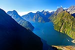
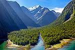
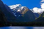
Milford Sound aerial view. Sinbad Gully & Mitre Peak (1683m) left, The Lion, Mt Pembroke and Harrison Cove centre, with Bowen River and Mt Grave right. Piopiotahi. Panorama, Milford Sound, Fiordland National Park, Southland District, Southland Region, New Zealand (NZ), stock photo.
 EMAIL TO FRIEND
- Location:
- Milford Sound, Fiordland National Park (other locations)
- District:
- Southland (see districts)
- Region:
- Southland (see regions)
- Country:
- New Zealand (NZ)
- Notes:
- Large digital file (7812 x 3323 pixels native, no interpolation) | Ratio (height:width) 1:2.35
- Photographer:
- Rob Suisted
- Image #:
- 40713TS00
Keywords (advanced)
Related images


Similar images


Random images


 left, The Lion, Mt Pembroke and Harrison Cove centre, with Bowen River and Mt Grave right. Piopiotahi. Panorama, Milford Sound, Fiordland National Park, Southland District, Southland Region, New Zealand (NZ)")