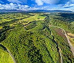
Makatote Railway Viaduct (2262m long, 79m high, built 1908) and State Highway 4 (SH4) over the Makatote River. Tongariro National Park and Mt Ruapehu beyond. Aerial view, Pokaka, Ruapehu District, Manawatu-Wanganui Region, New Zealand (NZ), stock photo.
These images are protected by copyright, but we license them to suit your needs. Click
'quick quote' to learn more...
Makatote Railway Viaduct (2262m long, 79m high, built 1908) and State Highway 4 (SH4) over the Makatote River. Tongariro National Park and Mt Ruapehu beyond. Aerial view, Pokaka, Ruapehu District, Manawatu-Wanganui Region, New Zealand (NZ) Stock Photo
Makatote Railway Viaduct (2262m long, 79m high, built 1908) and State Highway 4 (SH4) over the Makatote River. Tongariro National Park and Mt Ruapehu beyond. Aerial view, Pokaka, Ruapehu District, Manawatu-Wanganui Region, New Zealand (NZ)
 and State Highway 4 (SH4) over the Makatote River. Tongariro National Park and Mt Ruapehu beyond. Aerial view, Pokaka, Ruapehu District, Manawatu-Wanganui Region, New Zealand (NZ) stock photo.")


 and State Highway 4 (SH4) over the Makatote River. Tongariro National Park and Mt Ruapehu beyond. Aerial view, Pokaka, Ruapehu District, Manawatu-Wanganui Region, New Zealand (NZ)")