
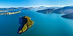
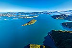
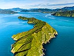
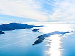
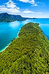
, Motuara Island, Long Island and Arapawa Island below Mount Furneaux (823m at left). Cook Strait and North Island beyond. Aerial view, Marlborough Sounds, Marlborough District, Marlborough Region, New Zealand (NZ) stock photo.")
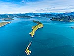
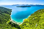
Ship Cove (Meretoto), Motuara Island, Long Island and Arapawa Island below Mount Furneaux (823m at left). Cook Strait and North Island beyond. Aerial view, Marlborough Sounds, Marlborough District, Marlborough Region, New Zealand (NZ), stock photo.
 EMAIL TO FRIEND
- Location:
- Marlborough Sounds (other locations)
- District:
- Marlborough (see districts)
- Region:
- Marlborough (see regions)
- Country:
- New Zealand (NZ)
- Notes:
- Large file (8141 x 6106 pixels native, no interpolation. | Ratio (height:width) 1:1.33
- Photographer:
- Rob Suisted
- Image #:
- 57725OP00
Keywords (advanced)
Related images


Similar images


Random images


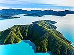
, Motuara Island, Long Island and Arapawa Island below Mount Furneaux (823m at left). Cook Strait and North Island beyond. Aerial view, Marlborough Sounds, Marlborough District, Marlborough Region, New Zealand (NZ)")