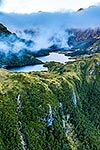
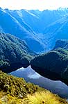
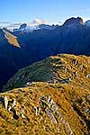
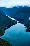
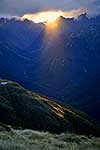
Wild Natives River headwaters seen from above the Taheke Creek (Waterfall Creek) saddle with Glaisnock River. Glaisnock Wilderness Area. Aerial, Fiordland National Park, Southland District, Southland Region, New Zealand (NZ), stock photo.
These images are protected by copyright, but we license them to suit your needs. Click
'quick quote' to learn more...
Wild Natives River headwaters seen from above the Taheke Creek (Waterfall Creek) saddle with Glaisnock River. Glaisnock Wilderness Area. Aerial, Fiordland National Park, Southland District, Southland Region, New Zealand (NZ) Stock Photo
Wild Natives River headwaters seen from above the Taheke Creek (Waterfall Creek) saddle with Glaisnock River. Glaisnock Wilderness Area. Aerial, Fiordland National Park, Southland District, Southland Region, New Zealand (NZ)
 saddle with Glaisnock River. Glaisnock Wilderness Area. Aerial, Fiordland National Park, Southland District, Southland Region, New Zealand (NZ) stock photo.")


 saddle with Glaisnock River. Glaisnock Wilderness Area. Aerial, Fiordland National Park, Southland District, Southland Region, New Zealand (NZ)")