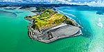
Milford township and airfield. Deepwater basin and Arthur River Valley beyond left. Mitre Peak at right. Milford Sound, Fiordland National Park, Southland District, Southland Region, New Zealand (NZ), stock photo.
These images are protected by copyright, but we license them to suit your needs. Click
'quick quote' to learn more...
Milford township and airfield. Deepwater basin and Arthur River Valley beyond left. Mitre Peak at right. Milford Sound, Fiordland National Park, Southland District, Southland Region, New Zealand (NZ) Stock Photo
Milford township and airfield. Deepwater basin and Arthur River Valley beyond left. Mitre Peak at right. Milford Sound, Fiordland National Park, Southland District, Southland Region, New Zealand (NZ)
 stock photo.")


")
