
 in cloud centre, Newton Creek left, Henderson Burn far right, Fiordland National Park, Southland District, Southland Region, New Zealand (NZ) stock photo.")
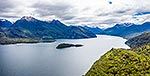
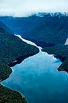
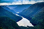
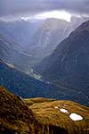
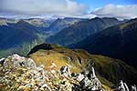
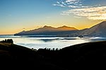
North Fiord of Lake Te Anau with Narrows and Glaisnock River Valley. Mt McDougall (1728m) in cloud centre, Newton Creek left, Henderson Burn far right, Fiordland National Park, Southland District, Southland Region, New Zealand (NZ), stock photo.
- Location:
- Fiordland National Park (other locations)
- District:
- Southland (see districts)
- Region:
- Southland (see regions)
- Country:
- New Zealand (NZ)
- Notes:
- Panorama file (6310 x 2892 pixels native, no interp.) | Ratio (height:width) 1:2.18
- Photographer:
- Rob Suisted
- Image #:
- 35099AT00
Keywords (advanced)
Related images

Similar images
Random images


 in cloud centre, Newton Creek left, Henderson Burn far right, Fiordland National Park, Southland District, Southland Region, New Zealand (NZ)")