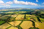
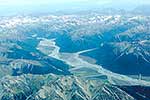
Southern Wairarapa farmland, with Ruamahanga River passing through to Lake Ferry (Onoke) and Palliser Bay and Cape Palliser behind. Aerial photo, Papatahi, South Wairarapa District, Wellington Region, New Zealand (NZ), stock photo.
These images are protected by copyright, but we license them to suit your needs. Click
'quick quote' to learn more...
Southern Wairarapa farmland, with Ruamahanga River passing through to Lake Ferry (Onoke) and Palliser Bay and Cape Palliser behind. Aerial photo, Papatahi, South Wairarapa District, Wellington Region, New Zealand (NZ) Stock Photo
Southern Wairarapa farmland, with Ruamahanga River passing through to Lake Ferry (Onoke) and Palliser Bay and Cape Palliser behind. Aerial photo, Papatahi, South Wairarapa District, Wellington Region, New Zealand (NZ)
 and Palliser Bay and Cape Palliser behind. Aerial photo, Papatahi, South Wairarapa District, Wellington Region, New Zealand (NZ) stock photo.")

 and Palliser Bay and Cape Palliser behind. Aerial photo, Papatahi, South Wairarapa District, Wellington Region, New Zealand (NZ)")
