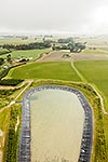
Dairy farmland conversions and pivot irrigation (bottom left) in the Manukerikia valley, with bony dry hills of the Raggedy Range beyond. Aerial view, Omakau, Central Otago District, Otago Region, New Zealand (NZ), stock photo.
These images are protected by copyright, but we license them to suit your needs. Click
'quick quote' to learn more...
Dairy farmland conversions and pivot irrigation (bottom left) in the Manukerikia valley, with bony dry hills of the Raggedy Range beyond. Aerial view, Omakau, Central Otago District, Otago Region, New Zealand (NZ) Stock Photo
Dairy farmland conversions and pivot irrigation (bottom left) in the Manukerikia valley, with bony dry hills of the Raggedy Range beyond. Aerial view, Omakau, Central Otago District, Otago Region, New Zealand (NZ)
 in the Manukerikia valley, with bony dry hills of the Raggedy Range beyond. Aerial view, Omakau, Central Otago District, Otago Region, New Zealand (NZ) stock photo.")

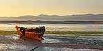


 in the Manukerikia valley, with bony dry hills of the Raggedy Range beyond. Aerial view, Omakau, Central Otago District, Otago Region, New Zealand (NZ)")