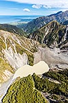
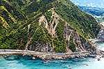
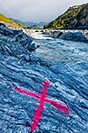
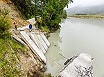
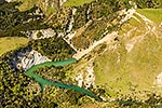
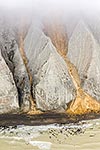
Earthquake formed river dam from slope failure above. Kaikoura m7.8 earthquake landslide geohazard to monitor downstream flooding. Note large cracks in slope. Medway River & Deep Stream confluence, Awatere Valley, Marlborough District, Marlborough Region, New Zealand (NZ), stock photo.
These images are protected by copyright, but we license them to suit your needs. Click
'quick quote' to learn more...
Earthquake formed river dam from slope failure above. Kaikoura m7.8 earthquake landslide geohazard to monitor downstream flooding. Note large cracks in slope. Medway River & Deep Stream confluence, Awatere Valley, Marlborough District, Marlborough Region, New Zealand (NZ) Stock Photo
Earthquake formed river dam from slope failure above. Kaikoura m7.8 earthquake landslide geohazard to monitor downstream flooding. Note large cracks in slope. Medway River & Deep Stream confluence, Awatere Valley, Marlborough District, Marlborough Region, New Zealand (NZ)
 stock photo.")


")