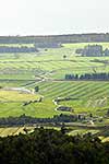
McLeans Conservation Area (Stewardship land), oddly shaped, amongst dairy farmland and beside the Greymouth Rubbish landfill. McLeans Creek and forest. Aerial view, Runanga, Grey District, West Coast Region, New Zealand (NZ), stock photo.
These images are protected by copyright, but we license them to suit your needs. Click
'quick quote' to learn more...
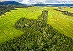
McLeans Conservation Area (Stewardship land), oddly shaped, amongst dairy farmland and beside the Greymouth Rubbish landfill. McLeans Creek and forest. Aerial view, Runanga, Grey District, West Coast Region, New Zealand (NZ) Stock Photo
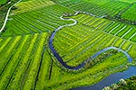
McLeans Conservation Area (Stewardship land), oddly shaped, amongst dairy farmland and beside the Greymouth Rubbish landfill. McLeans Creek and forest. Aerial view, Runanga, Grey District, West Coast Region, New Zealand (NZ)
, oddly shaped, amongst dairy farmland and beside the Greymouth Rubbish landfill. McLeans Creek and forest. Aerial view, Runanga, Grey District, West Coast Region, New Zealand (NZ) stock photo.")


, oddly shaped, amongst dairy farmland and beside the Greymouth Rubbish landfill. McLeans Creek and forest. Aerial view, Runanga, Grey District, West Coast Region, New Zealand (NZ)")