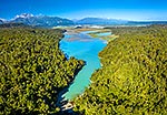
Lake Ianthe, Benford Bay. Aerial view with Mount Adams (2208m) prominent centre. Snow capped Southern Alps and Aoraki Mt Cook visible in distance, Harihari, Westland District, West Coast Region, New Zealand (NZ), stock photo.
These images are protected by copyright, but we license them to suit your needs. Click
'quick quote' to learn more...
Lake Ianthe, Benford Bay. Aerial view with Mount Adams (2208m) prominent centre. Snow capped Southern Alps and Aoraki Mt Cook visible in distance, Harihari, Westland District, West Coast Region, New Zealand (NZ) Stock Photo
Lake Ianthe, Benford Bay. Aerial view with Mount Adams (2208m) prominent centre. Snow capped Southern Alps and Aoraki Mt Cook visible in distance, Harihari, Westland District, West Coast Region, New Zealand (NZ)
 prominent centre. Snow capped Southern Alps and Aoraki Mt Cook visible in distance, Harihari, Westland District, West Coast Region, New Zealand (NZ) stock photo.")


 prominent centre. Snow capped Southern Alps and Aoraki Mt Cook visible in distance, Harihari, Westland District, West Coast Region, New Zealand (NZ)")