
, Karamea Bluffs (distant right), with Podge Creek and Radiant Range foothills (right). Mokihinui River mouth, town, Summerlea far left. Aerial panorama, Mokihinui, Buller District, West Coast Region, New Zealand (NZ) stock photo.")
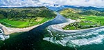
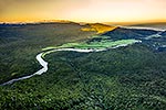
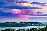
Forested view over Mumm Creek (centre), Karamea Bluffs (distant right), with Podge Creek and Radiant Range foothills (right). Mokihinui River mouth, town, Summerlea far left. Aerial panorama, Mokihinui, Buller District, West Coast Region, New Zealand (NZ), stock photo.
 EMAIL TO FRIEND
- Location:
- Mokihinui (other locations)
- District:
- Buller (see districts)
- Region:
- West Coast (see regions)
- Country:
- New Zealand (NZ)
- Notes:
- Ratio (height:width) 1:2.03
- Photographer:
- Rob Suisted
- Image #:
- 63981FG00
Keywords (advanced)
Related images
Random images

, Karamea Bluffs (distant right), with Podge Creek and Radiant Range foothills (right). Mokihinui River mouth, town, Summerlea far left. Aerial panorama, Mokihinui, Buller District, West Coast Region, New Zealand (NZ)")