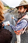
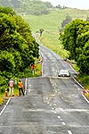
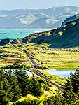
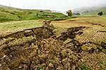
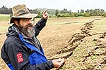
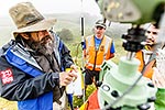
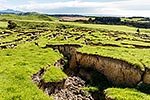
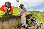
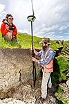
GNS earthquake scientist Russ Van Dissen mapping the Kekerengu Fault rupture as it crosses farmland, with Alex Hatem, a Californian geology student. Tirohanga Stream. Kaikoura M7.8 earthquake, Tirohanga, Kekerengu, Kaikoura District, Canterbury Region, New Zealand (NZ), stock photo.
These images are protected by copyright, but we license them to suit your needs. Click
'quick quote' to learn more...
GNS earthquake scientist Russ Van Dissen mapping the Kekerengu Fault rupture as it crosses farmland, with Alex Hatem, a Californian geology student. Tirohanga Stream. Kaikoura M7.8 earthquake, Tirohanga, Kekerengu, Kaikoura District, Canterbury Region, New Zealand (NZ) Stock Photo
GNS earthquake scientist Russ Van Dissen mapping the Kekerengu Fault rupture as it crosses farmland, with Alex Hatem, a Californian geology student. Tirohanga Stream. Kaikoura M7.8 earthquake, Tirohanga, Kekerengu, Kaikoura District, Canterbury Region, New Zealand (NZ)
 stock photo.")

")