
 stock photo.")
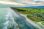
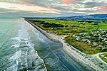
Te Horo Beach township or village. Aerial view looking over beach to farmland and Tararua Ranges beyond. Mangaone Stream crossing beach, Te Horo Beach, Kapiti Coast District, Wellington Region, New Zealand (NZ), stock photo.
 EMAIL TO FRIEND
- Location:
- Te Horo Beach (other locations)
- District:
- Kapiti Coast (see districts)
- Region:
- Wellington (see regions)
- Country:
- New Zealand (NZ)
- Notes:
- Ratio (height:width) 1:1.5
- Photographer:
- Rob Suisted
- Image #:
- 57484OP00
Keywords (advanced)
Related images


Similar images
Random images


")