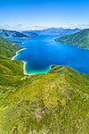
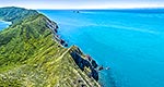
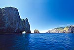
Bald Hill (258m) on Arapaoa (Arapawa) Island, used by Captain Cook as a lookout. Cook Strait and the North Island beyond, and Hura Point at right. Aerial view, Arapawa Island, Marlborough Sounds, Marlborough District, Marlborough Region, New Zealand (NZ), stock photo.
These images are protected by copyright, but we license them to suit your needs. Click
'quick quote' to learn more...
Bald Hill (258m) on Arapaoa (Arapawa) Island, used by Captain Cook as a lookout. Cook Strait and the North Island beyond, and Hura Point at right. Aerial view, Arapawa Island, Marlborough Sounds, Marlborough District, Marlborough Region, New Zealand (NZ) Stock Photo
Bald Hill (258m) on Arapaoa (Arapawa) Island, used by Captain Cook as a lookout. Cook Strait and the North Island beyond, and Hura Point at right. Aerial view, Arapawa Island, Marlborough Sounds, Marlborough District, Marlborough Region, New Zealand (NZ)
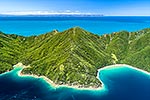
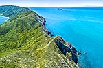
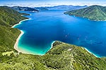
 on Arapaoa (Arapawa) Island, used by Captain Cook as a lookout. Cook Strait and the North Island beyond, and Hura Point at right. Aerial view, Arapawa Island, Marlborough Sounds, Marlborough District, Marlborough Region, New Zealand (NZ) stock photo.")

 on Arapaoa (Arapawa) Island, used by Captain Cook as a lookout. Cook Strait and the North Island beyond, and Hura Point at right. Aerial view, Arapawa Island, Marlborough Sounds, Marlborough District, Marlborough Region, New Zealand (NZ)")