
 stock photo.")
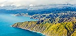
Wellington City aerial view panorama. Karori Sanctuary Zealandia left, City and Harbour centre, Airport right. Wind turbine centre below. Earthquake faultline visible along left of harbour, Wellington City, Wellington City District, Wellington Region, New Zealand (NZ), stock photo.
 EMAIL TO FRIEND
- Location:
- Wellington City (other locations)
- District:
- Wellington City (see districts)
- Region:
- Wellington (see regions)
- Country:
- New Zealand (NZ)
- Notes:
- Very large digital file (10903 x 5078 pixels native, no interpolation) | Ratio (height:width) 1:2.15
- Photographer:
- Rob Suisted
- Image #:
- 40539TC00
Keywords (advanced)
Related images

Similar images
Random images

")