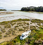
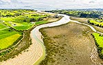
Turanga Creek and Wade Island (left), mangrove, salt marsh and tidal estuary downstream of Whitford township, looking out towards the Hauraki Gulf islands. Aerial view, Whitford, Auckland Region, New Zealand (NZ), stock photo.
These images are protected by copyright, but we license them to suit your needs. Click
'quick quote' to learn more...
Turanga Creek and Wade Island (left), mangrove, salt marsh and tidal estuary downstream of Whitford township, looking out towards the Hauraki Gulf islands. Aerial view, Whitford, Auckland Region, New Zealand (NZ) Stock Photo
Turanga Creek and Wade Island (left), mangrove, salt marsh and tidal estuary downstream of Whitford township, looking out towards the Hauraki Gulf islands. Aerial view, Whitford, Auckland Region, New Zealand (NZ)
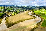
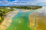
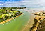
, mangrove, salt marsh and tidal estuary downstream of Whitford township, looking out towards the Hauraki Gulf islands. Aerial view, Whitford, Auckland Region, New Zealand (NZ) stock photo.")


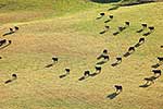
, mangrove, salt marsh and tidal estuary downstream of Whitford township, looking out towards the Hauraki Gulf islands. Aerial view, Whitford, Auckland Region, New Zealand (NZ)")