
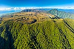
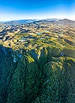
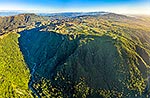
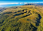
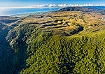
 left, and Mt Rochfort (1040m) right. Aerial view, Denniston, Buller District, West Coast Region, New Zealand (NZ) stock photo.")
Denniston-Stockton Plateau, seen from north looking past historic Denniston and mine entrance towards Mt William (1062m) left, and Mt Rochfort (1040m) right. Aerial view, Denniston, Buller District, West Coast Region, New Zealand (NZ), stock photo.
 EMAIL TO FRIEND
- Location:
- Denniston (other locations)
- District:
- Buller (see districts)
- Region:
- West Coast (see regions)
- Country:
- New Zealand (NZ)
- Notes:
- Very large file (9264 x 6623 pixels native, no interpolation). | Ratio (height:width) 1:1.39
- Photographer:
- Rob Suisted
- Image #:
- 63182EC00
Keywords (advanced)
Related images
Similar images
Random images


 left, and Mt Rochfort (1040m) right. Aerial view, Denniston, Buller District, West Coast Region, New Zealand (NZ)")