
 prominent behind, and snow capped Aoraki Mt Cook visible in distance. State Highway 6 (SH6) left, Harihari, Westland District, West Coast Region, New Zealand (NZ) stock photo.")
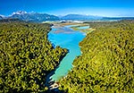
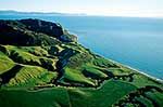
Lake Ianthe. Aerial view with Mount Adams (2208m) prominent behind, and snow capped Aoraki Mt Cook visible in distance. State Highway 6 (SH6) left, Harihari, Westland District, West Coast Region, New Zealand (NZ), stock photo.
 EMAIL TO FRIEND
- Location:
- Harihari (other locations)
- District:
- Westland (see districts)
- Region:
- West Coast (see regions)
- Country:
- New Zealand (NZ)
- Notes:
- Very large file (9649 x 5940 pixels native, no interpolation). | Ratio (height:width) 1:1.62
- Photographer:
- Rob Suisted
- Image #:
- 63261FL00
Keywords (advanced)
Related images

Random images


 prominent behind, and snow capped Aoraki Mt Cook visible in distance. State Highway 6 (SH6) left, Harihari, Westland District, West Coast Region, New Zealand (NZ)")