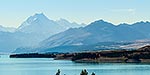
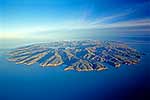
Looking across Lake Tekapo to Aoraki Mount Cook peak (3754m). Cass valley left, Gamack Range & Burnett Mountains centre. Aerial view, Aoraki / Mount Cook National Park, MacKenzie District, Canterbury Region, New Zealand (NZ), stock photo.
These images are protected by copyright, but we license them to suit your needs. Click
'quick quote' to learn more...
Looking across Lake Tekapo to Aoraki Mount Cook peak (3754m). Cass valley left, Gamack Range & Burnett Mountains centre. Aerial view, Aoraki / Mount Cook National Park, MacKenzie District, Canterbury Region, New Zealand (NZ) Stock Photo
Looking across Lake Tekapo to Aoraki Mount Cook peak (3754m). Cass valley left, Gamack Range & Burnett Mountains centre. Aerial view, Aoraki / Mount Cook National Park, MacKenzie District, Canterbury Region, New Zealand (NZ)
. Cass valley left, Gamack Range & Burnett Mountains centre. Aerial view, Aoraki / Mount Cook National Park, MacKenzie District, Canterbury Region, New Zealand (NZ) stock photo.")
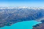


. Cass valley left, Gamack Range & Burnett Mountains centre. Aerial view, Aoraki / Mount Cook National Park, MacKenzie District, Canterbury Region, New Zealand (NZ)")