
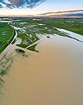
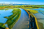
 underwater, and dairy farmland inundated by flood waters. Aerial panorama looking south over historic Opiki toll bridge towards Tararua Ranges, Opiki, Horowhenua District, Manawatu-Wanganui Region, New Zealand (NZ) stock photo.")
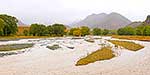
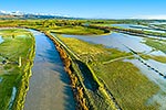
Farmland flooded by the Manawatu River. State Highway 56 (SH56, left) underwater, and dairy farmland inundated by flood waters. Aerial panorama looking south over historic Opiki toll bridge towards Tararua Ranges, Opiki, Horowhenua District, Manawatu-Wanganui Region, New Zealand (NZ), stock photo.
- Location:
- Opiki (other locations)
- District:
- Horowhenua (see districts)
- Region:
- Manawatu-Wanganui (see regions)
- Country:
- New Zealand (NZ)
- Notes:
- Very large file (12117 x 5247 pixels native, no interpolation. | Ratio (height:width) 1:2.3
- Photographer:
- Rob Suisted
- Image #:
- 57325EX00
Keywords (advanced)
Related images


Similar images


Random images


 underwater, and dairy farmland inundated by flood waters. Aerial panorama looking south over historic Opiki toll bridge towards Tararua Ranges, Opiki, Horowhenua District, Manawatu-Wanganui Region, New Zealand (NZ)")