
 stock photo.")
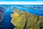
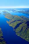
Indian Island in Tamatea Dusky Sound, site where Captain Cook recorded Maori inhabitants in 1773. Waka harbour at left. Passage, Prove, Stop and Anchor Islands behind. Aerial view, Fiordland National Park, Southland District, Southland Region, New Zealand (NZ), stock photo.
 EMAIL TO FRIEND
- Location:
- Fiordland National Park (other locations)
- District:
- Southland (see districts)
- Region:
- Southland (see regions)
- Country:
- New Zealand (NZ)
- Notes:
- Ratio (height:width) 1:1.24
- Photographer:
- Rob Suisted
- Image #:
- 64540OP00
Keywords (advanced)
Related images


Random images


")